Coordinate System
Advertisement
KMaps v.1.0
Color-coding maps made easy. KMaps is a mapping software to color-code maps on an XY coordinate system.KMaps Features: 1. Creates color-coded maps on an XY coordinate system 2. Reads from databases defined in an XML file 3. Imports and diplays
Advertisement
CHT - Cartesian HTML Table v.2.0
A JavaScript component that allows an ordinary HTML table to be visually browsed both in the 'X' and 'Y' axis, as a Cartesian Coordinate System.
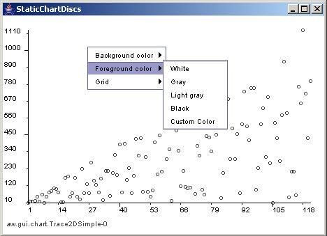
JChart2D v.3.2.2
JChart2D is a easy to use component for displaying two- dimensional traces in a coordinate system written in Java.
CADopia Professional Edition v.18.3.1.4063
CADopia 18 Professional is a full featured CAD software for engineers and architects. Supports AutoCAD DWG. New features include DWG 2018 support, new User Interface, multileader, block tools, dynamic coordinate system, export to Excel, and more.
Coordinate Calculator v.2 2
Coordinate Calculator is a geodetic coordinates calculator. Coordinate Calculator calculates Lat/Lon coordinates to/from coordinates in different projection, local datums (264 datums) and on different spheroids(33 spheroids).
Geo Data International Houses
For many countries house coordinates are present with coverage degrees of 100 percent. The geo data offered here are in high-precision quality and are present in several coordinate and reference systems (Geographic, UTM / WGS84, ETRS89). House Coordinates
TerraVision v.6.0
TerraVisionTM is an Open Source distributed, interactive terrain visualization system developed by SRI International.
Blue Marble Desktop v.2. 2. 2001
The Blue Marble Desktop is the all in one geospatial data management platform for Blue Marble's popular data transformation tools.
LEDAS 3D Geometric Solver v.5.0
It is commonly used as parametric engine for direct modeling of 3D geometry, assembly design, motion analysis, and other 3D geometric modeling applications.
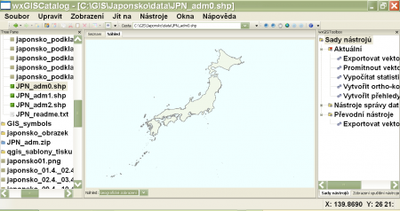
WxGIS Portable v.0.4.1
wxGIS is a useful application that allows you to manage and to organize multiple types of geographic information.
FlightDisplay v.7.0.0.3
'Flight Display' allows you to display data from a GPS logger on images of sectional maps (or other maps with longitude and latitude line references), to plan and display soaring tasks, to evaluate data from your GPS recorder competition style agains